Start/Finish: Demesne Picnic Area & Car Park, Wolsingham
Distance: 10.7 miles
Time Taken: 5 hours
Companion(s): Ailsa
Route Map:
Well the weather didn't look too promising but the forecast on the web said to expect only light showers so we finally decided to go for it. Sandwiches made, rucksacks checked and packed, maps and guidebook checked, route downloaded to GPS and off we went.
Following a fairly short but pleasant drive, we arrived at the car park, got togged up and set off.
It was very windy up here but the gravel track made for much better walking and, even though the wind was in our face, we stepped out quite happily, heading toward the Elephant Trees, across the heather moorlands. The track is very clear, the gravel turns to sand in some parts, and it ascends very gently on the approach route to the beech tree plantation. It was as we followed this path that we realised that we were surrounded by ground nesting birds and their babies - noisy curlew, grouse and many other species I'm afraid I don't know the names of (I must buy myself a bird book and a wildflower book so that I can tell what I'm looking at!). Anyway, suffice to say it took us quite some time to traverse this moorland as we spent lots of time trying to photograph the birds, missing them of course, and just watching them all in amazement.
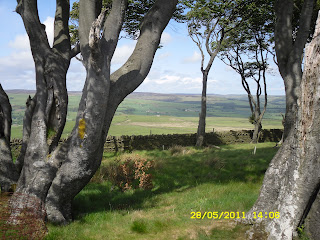
Well, we eventually made it for a close-up view of the Elephant Trees and their trunks which are heavily carved with the initials of previous visitors. You may be able to spot some evidence of this in the following photos but, to be honest I don't think my photography skills have quite captured this.
Continuing on our walk, we were now aiming to get to Frosterley so we carried on along the moorland path a little further before turning right to head on a track downhill, past some evidence of old quarry sites. The track all too soon turned into tarmac road again but the sun was now shining and we were heading down out of the strong wind :-)
A last look back to the Elephant Trees (perhaps from this view you can almost tell why they are called this - do you think they look a bit like a couple of elephants crossing the hill?).
We continue downhill to reach White Kirkley, then a fairly short uphill stretch of road to head out of White Kirkley before turning right to head downhill again to the bridge crossing the River Wear and the Weardale Railway and entering Frosterley via the Black Bull Inn.
This seemed to be the ideal spot for a toilet break and a refreshing glass of cider - we like to support local hostelries whenever possible! However, it wasn't too long before we were on our way again, this time heading along the low-level route following the River Wear and Weardale Railway back to Wolsingham.
Not far beyond this point, you lose sight of the river as the route takes you through a caravan site and then onto a seemingly never-ending trudge across field paths to eventually reach a flight of steps leading up to the road bridge crossing the Weardale Railway and then the River Wear back into Wolsingham.
A truly wonderful walk, throughly enjoyed by both of us and, to top it all, we didn't get rained on :-)


No comments:
Post a Comment